
ESPAÑOL
Grin Grin Park is a pilot project designed by Toyo Ito. It is located on Island City, in Hakata Bay, north of Fukuoka, Kyushu, in South West Japan. In this exciting and innovative project, conceived between 2002-03 and built between 2004-05, Ito combined the site and the building design by means of a multidimensional walk-through experience.

ISLAND CITY
The city of Fukuoka is located in a prime position in East and South East Asia, given its proximity to major urban centers like Busan in Korea and Shanghai in China as well as connections to Taiwan, the Philippines, Vietnam and Singapore.
Island City is an artificial island located northeast of Fukuoka, in order to reinforce the functions of the port, create a whole new industry, improve the traffic system east of Fukuoka and in turn create a comfortable urban space to house a pleasant residential environment.

GRIN GRIN PARK
Amid Island City is a park surrounding a bean-shaped pond. It is noteworthy that the location of the park is not directly on the waterfront but landlocked, a decision perhaps influenced by the cold winds that blow over Fukuoka in winter .

The park has three areas: the pond, around which other elements are organized, the greenhouse, located west and that somehow protects against the sea breeze, and the other amenities that surround the pond, such as playgrounds , promenades, etc.

As we approach the greenhouse, the unique urban furniture indicates that we are standing in a special place. The play grounds, the restrooms and even the seats have sculptural forms in addition to their function.


Not all of them are successful, though, such as these circular seats that remain empty because they are very uncomfortable and do not favor any activity.

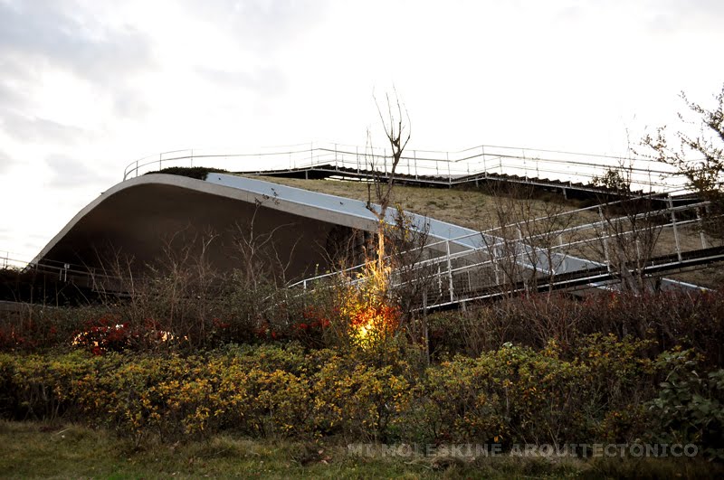
However the most striking structure at the Grin Grin Park is the greenhouse. Ito's project aims to integrate architecture to the park's landscape. From the pond, the architecture seems to blend with the site, generating a topography that is a combination of the natural and built, perhaps an analogy to the mountainous character of the country.


Another architect, Emilio Ambasz, has a proposal not far from here that shares the idea embedding a building in a construction, using terraces to vertically extend a park along a building, the ACROS Fukuoka International Hall. However, Ito's proposal goes further by providing a kinetics experience in the visitor, modelling the park on the basis of the topological relationships generated on its surface. In any case, the visit evoked me the experience of walking though FOA 's Passenger Terminal in Yokohama rather than that of Ambasz's proposal .

Working in partnership with Sekkei Sougo Kenkyujo, Ito chose the image of circles (waves) radiating from the Central Park to the whole island, as the basis of his proposal. The enormous circles became craters and mounds to cover various human activities and to produce incremental topological changes to the Central Park. Therefore the architecture is shown throughout undulating
sequences in spiral, integrating itself with the undulations of the ground rather than standing out as an architectural object.
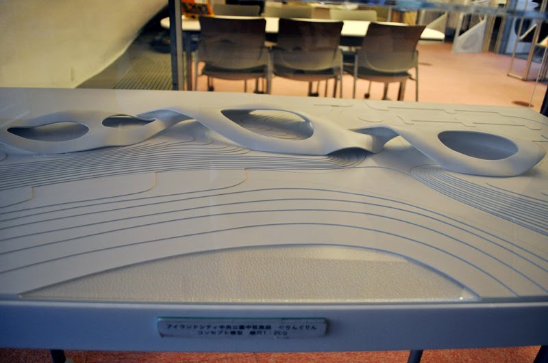 In
this conceptual model the genesis idea can be seen: a ribbon is twisted
twice generating spaces illuminated by three elliptical skylights.
In
this conceptual model the genesis idea can be seen: a ribbon is twisted
twice generating spaces illuminated by three elliptical skylights.
The architecture has a covered an area of approximately 5,000 m2, and it is a central facility located in the park. There are 3 spaces prepared around the gardens with flowers and plants, each with an area of 900 to 1000 m2.

 It is interesting to observe how the architect uses the building to define the boundary of the park, but at the same time he makes it quite permeable, being
possible to walk through it, climb it, see through it or enter inside.
It is interesting to observe how the architect uses the building to define the boundary of the park, but at the same time he makes it quite permeable, being
possible to walk through it, climb it, see through it or enter inside. 


These three spaces are concatenated by routes that not only remain at ground level or enter inside the building, but that are elevated forming bridges and walkways and following the surface of the roof, offering various visual experiences.


Green spaces are mixed with the built spaces in a way in which one can not only appreciate the greenery but also read books, have lunch or participate in workshops.


It is precisely this sequence that gives the user freedom to experience the building in various forms and from multiple points of view. Walkways offer views of the park connecting the interior and exterior, following the topography of the roof. (watch this sequence in the video tour at the end of the post).


The concrete slab and the skylights or glass partitions switch roles as ceiling and walls, but whereas the windows ensure visual integration with the park, the skylights help to highlight the spaces grouped around the planters under the game of light.

 Photo courtesy of scarletgreen

The skylights are controlled automatically according to the ambient temperature, allowing ventilation on hot days or being closed in case of rain or cold weather. The cantilever structure also offer protection from the summer heat. By contrast, during the winter, the tropical temperature required inside the building is controlled by heaters.


Although it is a relatively small project, Toyo Ito takes the opportunity to highlight its theoretical concepts in relation to architecture and nature. This relationship is based on the conception of the natural world and the architecture and it had already been expressed by Ito previously in his Sendai Mediatheque , and also in the Library at the University of Tama , despite the formal difference between them. Their relationship with nature is not only poetic, but emphasizes its concern with the technology of our era.

But this communion between architecture and nature is it based solely on sensory and phenomenological parameters? Is it the same experience to walk around the park that Grin Grin Park than to visit the Yoro Park, "Site Reversible Destiny" by Shusaku Arakawa , for example? Certainly not, Ito set his own rules, and followed them precisely.
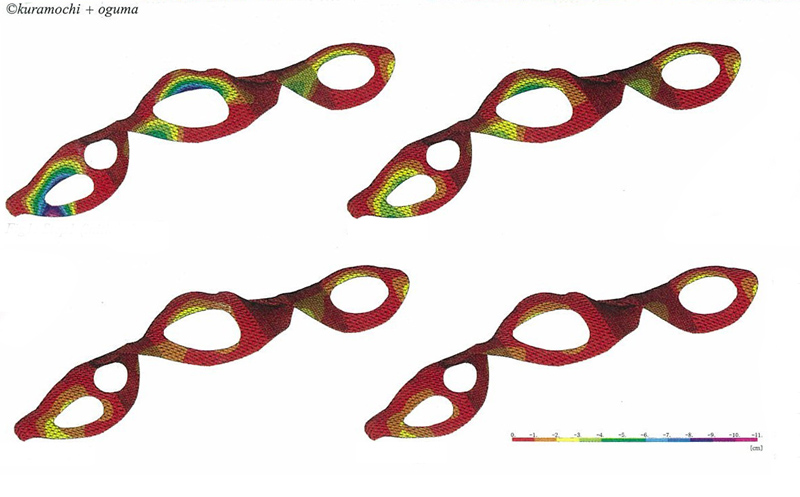
The technique that enables this design is a completely unique structure, called the method of shape analysis. First, a form is chosen, whose variations are simulated on the computer so that the load of torsion, energy of tension and distortion would be minimal. Then, a structurally optimal form is obtained as an evolved form. Feedback to this process are exchanged several times between architectural and structural designs. Finally the result was an architecture with a shell of 40 cm reinforced concrete.

One of the most important contributions of the building (beyond
its architectural achievements) is its social role, particularly regarding to education.
The collection of various exotic species of flora and fauna provide
opportunities for people to expand their knowledge of science while
touring an enjoyable and interesting building.
In the following video you can see more photos of the park and the building as well as a sequence of the walk-through .
SEE ALSO
- OTHER WORKS BY TOYO ITO
- Egg of the Winds, Yokohama, Japan. (1991)
- Mikimoto Ginza 2, Tokyo, Japan. (2005)
- Sendai Mediatheque, Sendai, Japan. (2001)
- Shinonome Canal Court, Tokyo, Japan. With Kengo Kuma and others (2004)
- Tama Art University Library, Tokyo, Japan. (2007)
- Tod's Omotesando, Tokyo, Japan. (2002-04)
- Tower of the Winds, Yokohama, Japan. (1986)
- Za Koenji Theater, Tokyo, Japan. (2009)
- VanDusen Visitor Centre, Vancouver, Canada. Perkins + Will (2010-11)
- Garden of Fine Arts, Kyoto, Japan. Tadao Ando (1990)
- Yorkville Park, Toronto
- Westminster Pier Park, New Menstminster, Canada (2012)
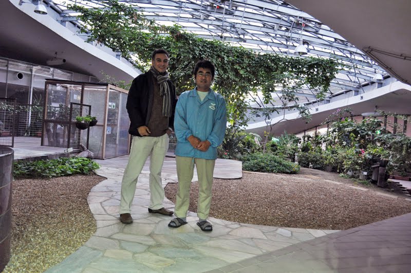 As usual, I arrived to the site late, just when they were about to close. After begging this gentleman, telling him that I came from the other side of the
planet (which is technically true) just to see this building (which was not actually true), he agreed to let me in, and I accompanied him as he was closing the facility. When
I told him that I had a blog on architecture, he became very interested and very kindly photocopied me some literature, and made me promise I would post
about the Grin Grin. Well, it took some time but I finally fulfilled my promise.
As usual, I arrived to the site late, just when they were about to close. After begging this gentleman, telling him that I came from the other side of the
planet (which is technically true) just to see this building (which was not actually true), he agreed to let me in, and I accompanied him as he was closing the facility. When
I told him that I had a blog on architecture, he became very interested and very kindly photocopied me some literature, and made me promise I would post
about the Grin Grin. Well, it took some time but I finally fulfilled my promise.